


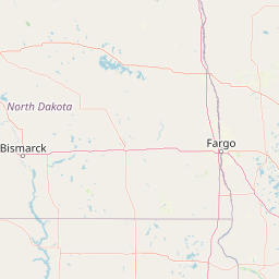


Departure Airport Brainerd - United States (BRD) Destination Airport Cortez - United States (CEZ)
Departure Airport
Brainerd - United States (BRD)

Current Time: CDT
Destination Airport
Cortez - United States (CEZ)
Current Time: MDT
Distance: 1565.07 km / 972.49 miles
www.distanceairport.com
Estimated Flight Duration: 1h 57m
Calculate Distance Between Airports
Welcome to our comprehensive platform, designed to serve travelers, logistics professionals, aviation enthusiasts, and anyone in between. Our primary aim is to offer you a seamless way to calculate the exact distance between any two airports worldwide.
Other distances
From MTJ to SOC From IXL to RYO From MTY to LAI From NTL to CHX From BKL to GLA From KNX to AGU From SHJ to CAG From BKI to BTM From RAB to KGA From CIH to KWJ
© Doorify Tech S.r.l. - 2023-2025 - Made by
Trouble Flight