


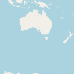


Departure Airport Lewiston - United States (LWS) Destination Airport Babo - Indonesia (BXB)
Departure Airport
Lewiston - United States (LWS)

Current Time: PDT
Destination Airport
Babo - Indonesia (BXB)
Current Time: GMT+9
Distance: 11703.36 km / 7272.13 miles
www.distanceairport.com
Estimated Flight Duration: 14h 38m
Calculate Distance Between Airports
Welcome to our comprehensive platform, designed to serve travelers, logistics professionals, aviation enthusiasts, and anyone in between. Our primary aim is to offer you a seamless way to calculate the exact distance between any two airports worldwide.
Other distances
From BKI to AGS From OTP to MEG From KRO to RKV From CAH to IOS From YPH to IWA From BBN to KRN From BNK to IPC From BJZ to NDC From DEN to LEA From KBC to JAK
© Doorify Tech S.r.l. - 2023-2025 - Made by
Trouble Flight